The European AlpArray initiative, launched in 2015, aims to improve our understanding of the geological development of the Alps and the seismic risk in the Alps-Apennines-Carpathians-Dinarides mountain system. The initiative integrates current Earth research with high-resolution geophysical imaging of 3D structures and the physical properties of the lithosphere and upper mantle, focusing on top seismological measurements. As part of this project, the AlpArray Gravity Research Group (AAGRG) was established, the aim of which was to compile a homogeneous gravity data set in the wider Alpine region. This database will be used to create a basic Bouguer anomaly map and to subsequent interpretations of the geological structure of the whole area.
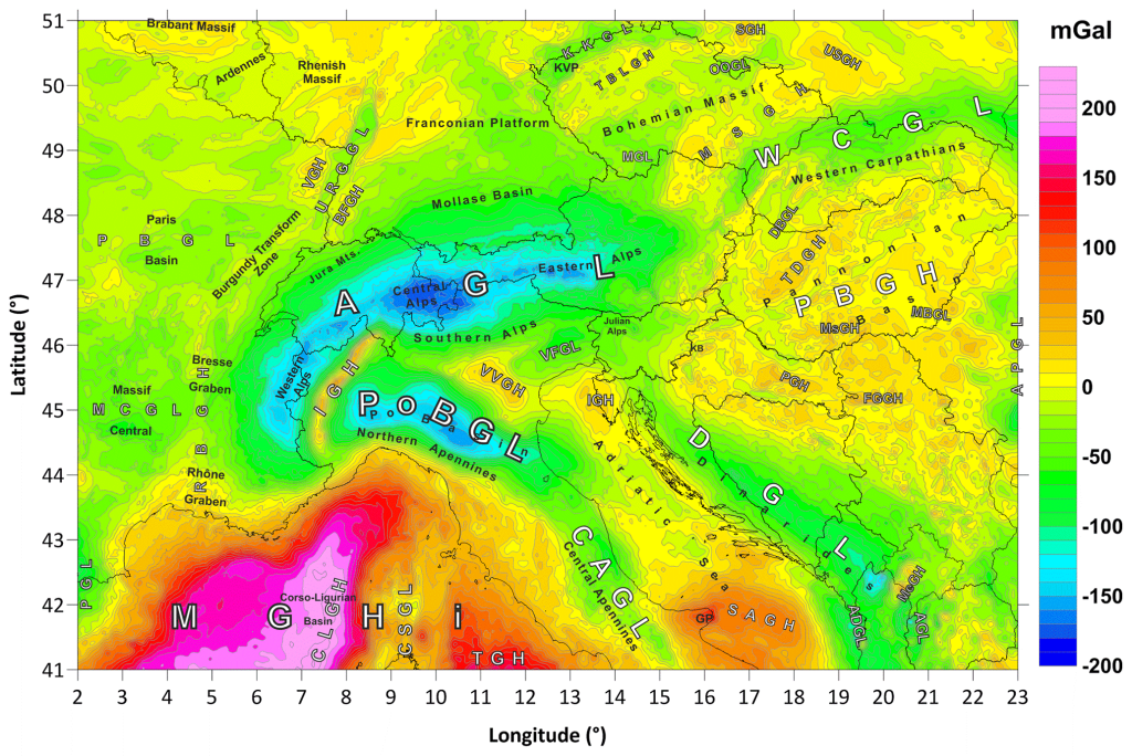
The primary output of the project was recently published in the world-leading journal Earth System Science Data (https://www.earth-system-science-data.net/). The article “The first pan-Alpine surface-gravity database, a modern compilation that crosses frontiers” is the result of several years of intensive cooperation between European gravimetrists and geodesists. Slovak researchers Mgr. P. Zahorec, PhD., Ing. J. Papčo, PhD, prof. RNDr. R. Pašteka, PhD. and prof. RNDr. M. Bielik, DrSc. (and their PhD. students, e.g. Mgr. E. Nogová) built a natural authority in this group through their own activity and work, which led them to play a leading scientific role in the creation of the first pan-Alpine surface gravity database. The published map of complete Bouguer anomalies of the wider Alpine region is homogeneous for the first time and compiled according to state-of-the-art criteria in terms of input data sets, applied methods and all corrections of the measured gravity acceleration (topography, bathymetry, atmosphere, special emphasis was placed on the gravitational effect of large mountain lakes, which are located in the studied area).
The first interpretations of the new gravity map show that the resolution of gravity anomalies is appropriate and fully sufficient for integrated modelling of local, regional to continental geological structure of the European lithosphere, as well as for its joint inversion with other, especially seismic data sets. The data is published through GFZ Data Services. The article can be viewed on the web page: https://essd.copernicus.org/articles/13/2165/2021/.
Text: Pavol Zahorec