Basic research
VAJDA, Peter – FOROUGHI, Ismael – VANÍČEK, Petr – KINGDON, D. R. – SANTOS, Marcelo – SHENG, Michael – GOLI, Mehdi. Topographic gravimetric effects in earth sciences: Review of origin, significance and implications. In Earth-Science Reviews, 2020, vol. 211, art. no. 103428. (2019: 9.724 )
We present a comprehensive review of the origin, significance and implications of topographic effects in Earth Sciences in the field of gravimetry. We illustrate the sizes and shapes (spatial properties) of these effects, discuss their relevance and impacts in the areas of geodesy, geophysical structural studies (exploration and prospection), and in geodynamics with a focus on volcano geodesy.
PETRÍK, Igor – JANÁK, Marian – KLONOWSKA, Iwona – MAJKA, Jarosław – FROITZHEIM, Nikolaus – YOSHIDA, Kenji – SASINKOVÁ, Vlasta – KONEČNÝ, Patrik – VACULOVIČ, Tomáš. Monazite behaviour during metamorphic evolution of a diamond-bearing gneiss: a case study from the Seve Nappe Complex, Scandinavian Caledonides. In Journal of Petrology, 2019, vol. 60, no. 9, p. 1773-1796. (2018: 3.380)
Monazite is an important mineral for dating of metamorphic processes – ultrahigh pressure (UHP) metamorphism. During metamorphic evolution monazite adapts its composition to the changing mineral assemblage especially by its heavy rare earth element contents. We studied this process in diamond-bearing gneiss containing monazite, from Saxnäs in the Seve Nappe Complex of the Scandinavian Caledonides which attained metamorphic conditions of 4.2 GPa and 830 – 840°C (Petrík et al. 2019). Monazite was formed from allanite during deep subduction (ca.150 km) of continental crust and during exhumation monazite was partialy dissolved in melt. Monazite composition shows negative Eu anomalies, which we interpret to be inherited from the source rock, not reflecting the coexistence with plagioclase which is unstable at UHP conditions. Our results suggest that the effect of whole-rock composition may be more important than that of coexisting phases.
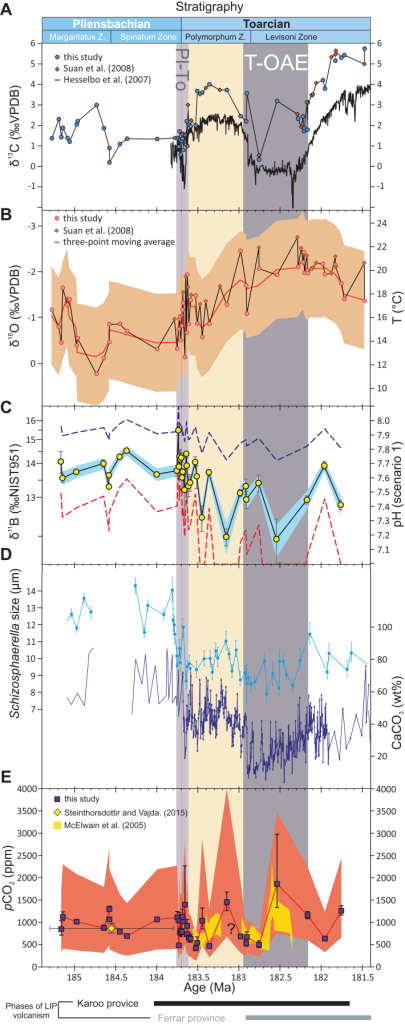
MÜLLER, Tamás – JURÍKOVÁ, Hana – GUTJAHR, M. – TOMAŠOVÝCH, Adam – SCHLŐGL, Ján – LIEBETRAU, V. – DUARTE, L. V. – MILOVSKÝ, Rastislav – SUAN, G. – MATTIOLI, Emanuela – PITTET, B. Ocean acidification during the early Toarcian extinction event: Evidence from boron isotopes in brachiopods. In Geology, 2020, vol. 48, no. 12, p. 1184-1188. (2019: 4.768 – IF).
MÜLLER, Tamás – KARANCZ, Szabina – MATTIOLI, Emanuela – MILOVSKÝ, Rastislav – PÁLFY, József – SCHLŐGL, Ján – SEGIT, T. – ŠIMO, Vladimír – TOMAŠOVÝCH, Adam. Assessing anoxia, recovery and carbonate production setback in a hemipelagic Tethyan basin during the Toarcian Oceanic Anoxic Event (Western Carpathians). In Global and planetary change, 2020, vol. 195, art. no. 103366. (2019: 4.448 – IF).
Extensive volcanic activity from the Karoo-Ferrar large igneous province (southern Africa and Antarctica) affected marine and terrestrial environments during the Early Jurassic, at the end of the Pliensbachian and during the early Toarcian. The release of CO2 to the atmosphere led to abrupt warming of seawater and left two major negative δ13C anomalies in the stratigraphic record worldwide. These two (late-Pliensbachian and early Toarcian) events were associated with a significant decline in carbonate production, with a collapse in the development of tropical reefs, with extensive anoxia, and extinction of benthic and planktonic organisms. One of the hypotheses that explains this extinction is seawater acidification. However, this hypothesis has never been directly tested. In our article published in Geology, we have calibrated pH of seawater its potential saturation with respect to calcite and aragonite on the basis of δ11B measured in brachiopod shells (collected in the Lusitanian Basin in Portugal). The stratigraphic record indeed shows a decline in δ11B in beds corresponding to the late-Pliensbachian and early Toarcian events, and thus support the acidification hypothesis. The negative values in δ11B also coincide with the decline in CaCO3 concentrations and with the decline in size of calcareous nannoplankton. In another article published in Global and Planetary Change, we have documented the development anoxic conditions during these two events in an oceanic section in the Western Carpathians.
Applied research
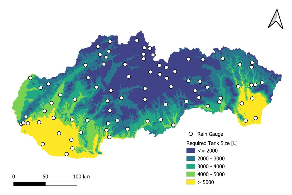
ONDERKA, Milan – PECHO, Jozef, RNDr. – NEJEDLÍK, Pavol. On how rainfall characteristics affect the sizing of rain barrels in Slovakia. In Journal of Hydrology : Regional Studies, 2020, vol. 32, article number100747. (2019: 3.645 – IF)
The article analyzes spatial variability of atmospheric precipitation and its impliocations for the design of small-scale water harvesting projects. Torrential rains and periods of prolonged drought are becoming more intense and frequent phenomena in Slovakia. Rainwater harvesting measures reduce and slow down the runoff of water from paved surfaces such as roofs and parking lots, and at the same time positively affect the microclimate in cities during hot summer days. In our recent study (https://doi.org/10.1016/j.ejrh.2020.100747) we analyzed rainfall data in order to provide location-specific design parameters for rainwater tanks. With the help the published statistics of rain episodes, every homeowner in Slovakia can now estimate the optimal volume of the rainwater tank for a desired location, rooftop catchment area and the water consumption rate.
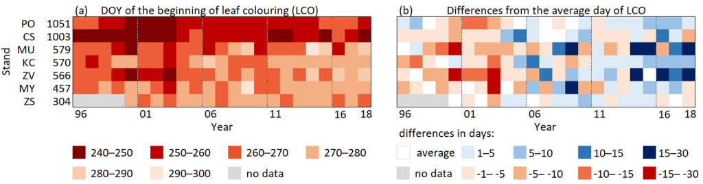
LUKASOVÁ, Veronika – VIDO, Jaroslav – ŠKVARENINOVÁ, Jana – BIČÁROVÁ, Svetlana – HLAVATÁ, Helena – BORSÁNYI, Peter – ŠKVARENINA, Jaroslav**. Autumn phenological response of european beech to summer drought and heat. In Water, 2020, vol. 12, no. 9, article number 2610. (2019: 2.544 – IF).
The changes in precipitation and temperature regimes brought on by the current climate change have influenced ecosystems globally. Using phenological and meteorological data from 1996–2018, we analysed changes of the onset of leaf colouring in European beech (Fagus sylvatica, L.) as an important native tree species growing throughout Europe. While at the beginning of the studied period the earliest onset of leaf colouring of European beech was observed at low altitudes, over the last decade it was observed to start at the middle altitudes concurrently with the low altitudes or even later. At present, the increase in precipitation and rising temperatures are advantageous for beech at most stands at middle to high altitudes. There the trend of delayed onset of leaf colouring is significant. However, at the low altitudes, we discovered a significant negative effect of drought prior to the leaf colouring leading to an earlier onset. This indicates that the meteorological drought conditioned by lower precipitation total and higher evapotranspirative demands in the warmer climate advances the leaf senescence and the growing season ends earlier. Furthermore, we revealed the first signs of the commencing negative effect of drought at mid-altitudes at stands with lower (below 700 mm) annual precipitation total. The ongoing warming trend of summer months suggests a continual increase of evapotranspiration in the next decades and thus further intensification of droughts, which will limit the growing season duration of beech at the low as well as middle altitudes.
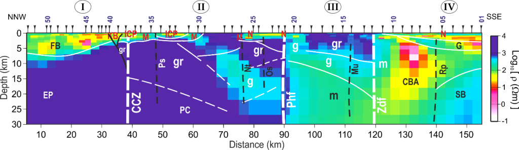
BEZÁK, Vladimír – PEK, Josef – VOZÁR, Ján – MAJCIN, Dušan – BIELIK, Miroslav – TOMEK, Čestmír. Geoelectrically distinct zones in the crust of the Western Carpathians: A consequence of Neogene strike-slip tectonics. In Geologica Carpathica, 2020, vol. 71, no. 1, p. 14-23. (2019: 1.535 – IF).
Based on magnetotelluric modelling and other geophysical methods (seismic, gravimetric, partly geothermic), significant interfaces in the crust of the Western Carpathians were identified. These are steeply inclined tectonic interfaces, where the crustal blocks with different physical properties and thus different geological composition meet. Interfaces represent mostly Neogene transform shear zones, although some of them may have been older origin. These tectonic zones separate the European platform with the overthrusted outer flysch units from the inner Western Carpathians and the sub-blocks within the Western Carpathians (northern granitized block, the middle formed mainly by metamorphites and the southern altered by young volcanic and hydrothermal processes).
Research related to international collaboration
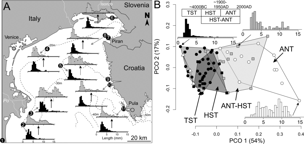
TOMAŠOVÝCH, Adam – ALBANO, Paolo G. – FUKSI, Tomáš – GALLMETZER, Ivo – HASELMAIR, Alexandra – KOWALEWSKI, Michał – NAWROT, Rafał – NERLOVIĆ, Vedrana – SCARPONI, Daniele – ZUSCHIN, Martin. Ecological regime shift preserved in the Anthropocene stratigraphic record. In Proceedings of the Royal Society : B – Biological Sciences, 2020, vol. 287, no. 1929, art. no. 20200695. (2019: 4.637 – IF).
It is assumed that the stratigraphic record of continental shelves is too coarse (with centennial-millennial resolution) and incomplete to detect ecological processes taking place at yearly or decadal scales. However, we found that the youngest (Anthropocene) stratigraphic record on the northern Adriatic continental shelf provides a relatively high, decadal-scale stratigraphic resolution that accurately documents an abrupt ecological change affecting benthic communities on this shelf during the twentieth century. We showed that the magnitude and the duration of the twentieth century shift in body size of the bivalve Corbula gibba is unprecedented given that regional populations of this species were dominated by small-size classes throughout the Holocene. Larger size and higher abundance of bivalves coincide with an increase in the frequency of seasonal hypoxia during the late 20th century. Importantly, the higher frequency of hypoxic events is coupled with a decline in the depth of intense sediment mixing by burrowing benthic organisms from several decimetres to less than 20 cm, significantly improving the stratigraphic resolution of the Anthropocene fossil record. In the absence of this decline in the depth of bioturbation, the stratigraphic resolution would be poor even at sites with high sedimentation rates.
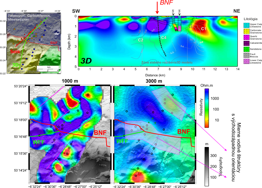
VOZÁR, Ján – JONES, Alan G. – CAMPANYA, Joan – YEOMANS, Chris – MULLER, Mark R. – PASQUALI, Riccardo. A geothermal aquifer in the dilation zones on the southern margin of the Dublin Basin. In Geophysical Journal International, 2020, vol. 220, issue 3, p.1717-1734. (2019: 2.574 – IF).
The geoelectric images of subsurface conductivity were derived based on magnetotelluric (MT) data from the Newcastle area near Dublin in Ireland for geothermal potential estimation. The conductivity models and their interpretation with existing seismic profiles and borehole information in the area reveals that the Blackrock–Newcastle Fault (BNF) zone is visible in the models as a conductive feature down to depths of 4 km. The investigated area below Newcastle can be divided into two domains in different depths, formed as depth zones. The first zone, from the surface down to 1–2 km, is dominated by NE–SW oriented conductors connected with shallow faults or folds probably filled with less saline waters. The conductors are also crossing the surface trace of the BNF. The second depth domain can be identified for depths of 2–4 km, where structures are oriented along the BNF and the observed conductivity is lower. The deeper conductive layers are interpreted as geothermal-fluid-bearing rocks. Porosity and permeability estimations from the lithological borehole logs indicate the geothermal potential of the bedrock, to deliver warm water to the surface. The rock permeability for fluids estimation, based on Archie’s law for porous structures and synthetic studies of fractured zones, suggests a permeability in the range, which is prospective for geothermal energy exploitation.
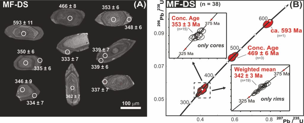
BROSKA, Igor – SVOJTKA, Martin. Early Carboniferous successive I/S granite magmatism recorded in the Malá Fatra Mountains by LA-ICP-MS zircon dating (Western Carpathians). In Geologica Carpathica, 2020, vol. 71, no. 5, p. 391-401. (2019: 1.535 – IF)
Granite dating, carried out on the basis of cooperation with the Geological Institute of the Czech Academy of Sciences, shows multistage formation of the Malá Fatra granites in the range of 11 million years (from 353 mil. to 342 million years). The intrusion of a hot granite body into the Earth upper crust 342 million years ago thermally affected older granites as illustrate the origin of their newly-formed zircon rims on older cores.