Basic research
DHAVAMANI, Ramachandran – KYŠKA-PIPÍK, Radovan – SOČUVKA, Valentín – ŠURKA, Juraj – STAREK, Dušan – MILOVSKÝ, Rastislav – UHLÍK, Peter – VIDHYA, Marina – ŽATKOVÁ, Lucia – KRÁĽ, Pavol. Sub-bottom and bathymetry sonar inspection of postglacial lacustrine infill of the alpine lakes (Tatra Mts., Slovakia). In Catena, 2022, vol. 209, art. no. 105787. (2021: 6.367 – IF, Q1 – JCR, 1.391 – SJR, Q1 – SJR). ISSN 0341-8162. https://doi.org/10.1016/j.catena.2021.105787
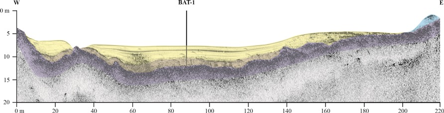
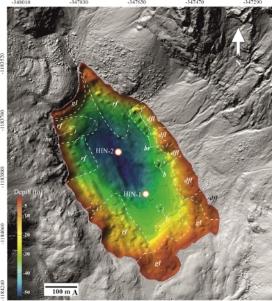
The postglacial infill of the Tatra Mts. lakes was investigated using two types of sonar. AUVEM sonar mapped the lake bottom, while chirp sonar explored the thickness of the sedimentary infill. For the correct interpretation of the sonar research, boreholes were drilled into the lake bottom.
The varves are the oldest lake sediments, which were formed during the melting of glaciers. The end of their sedimentation defines the disappearance of the glacier in the given valley and this interpretation shifts the glacier extinction in the Tatra Mts. to a younger period than is considered today. Organic sediments of which the sedimentation continues to this day, were deposited on the varves. However, this basic sedimentation scheme is very variable between the lakes in the content and thickness of the sediments (from 0.7m to >11m), and which is additionally affected by taluses and rockfalls, which are most complexly developed in the Veľké Hincovo pleso surrounding. Sonar research has also shown rockfalls that have no indications in the lake surrounding and are the result of intralacustrine landslide. The identification of geodynamic phenomena shows a strong facies correlation and an occurrence of the phenomena is random in time, which means that their origin does not correspond to climatic changes. The presence of the bottom springs of the non-karstic origin, which effectively disturb the fine clastic and organic matter deposition, was documented for the first time.
LUKASOVÁ, Veronika – BIČÁROVÁ, Svetlana – BUCHHOLCEROVÁ, Anna – ADAMČÍKOVÁ, Katarína. Low sensitivity of Pinus mugo to surface ozone pollution in the subalpine zone of continental Europe. In International Journal of Biometeorology, 2022, vol. 66, iss. 10, p. 2311-2324. (2021: 3.738 – IF, Q2 – JCR, 0.801 – SJR, Q1 – SJR). ISSN 0020-7128. https://doi.org/10.1007/s00484-022-02359-2
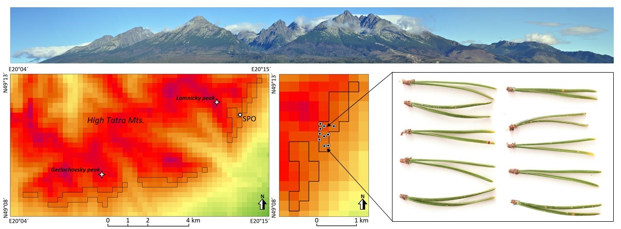
High altitudes have been exposed to enhanced levels of surface ozone (O3) concentrations over recent decades compared to the pre-industrial era. In this paper, we explored the reaction of Pinus mugo to O3-induced stress in the continental climate of an ozone-rich mountain area in the High Tatra Mountains.
Results showed that the visible O3 injury of samples collected at study sites was low and the symptoms of injury caused by other biotic and abiotic factors prevailed. In addition, the correlation analyses between NDVI from remote sensing data and the climatic factors indicated a significant and positive relationship with photosynthetic active radiation, stomatal conductance and temperature factor in summer.
Therefore, we concluded that the positive effect of climate conditions, which support the growth processes of Pinus mugo, may suppress the negative effect of the O3 doses.
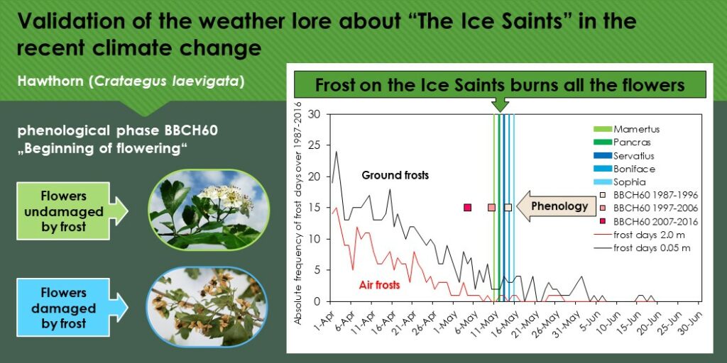
ŠKVARENINOVÁ, Jana – LUKASOVÁ, Veronika – BORSÁNYI, Peter – KVAS, Andrej – VIDO, Jaroslav – ŠTEFKOVÁ, Jaroslava – ŠKVARENINA, Jaroslav. The effect of climate change on spring frosts and flowering of Crataegus laevigata – The indicator of the validity of the weather lore about “The Ice Saints”. In Ecological Indicators, 2022, vol. 145, december, 109688. (2021: 6.263 – IF, Q1 – JCR, 1.284 – SJR, Q1 – SJR). ISSN 1470-160X https://doi.org/10.1007/s00484-022-02359-2
During the flowering time in spring, late frosts are one of the most dangerous meteorological phenomena leading to damage to crops. In this work, we analysed the risk of late frost damage during the proverb “Frost on the Ice Saints burns all the flowers” on hawthorn (Crataegus laevigata) blooming flowers in recent climate change. Results indicate that the probability of occurrence of late frosts on at least one day of “The Ice Saints” remains high.
Climate change caused the beginning of the flowering of Crataegus laevigata to start significantly earlier by 3.6 to 6.2 days per decade. As a consequence, flowering occurs during the proverb at most altitudes and thus the risk of late frost damage to flowers is highly probable in the present.
BROSKA, Igor – JANÁK, Marian – SVOJTKA, Martin – YI, Keewook – KONEČNÝ, Patrik – KUBIŠ, Michal – KURYLO, Sergiy – HRDLIČKA, Martin – MARASZEWSKA, Maria. Variscan granitic magmatism in the Western Carpathians with linkage to slab break-off. In Lithos, 2022, vol. 412, art. no. 106589. (2021: 4.020 – IF, Q2 – JCR, 1.630 – SJR, Q1 – SJR). ISSN 0024-4937. Dostupné na: https://doi.org/10.1016/j.lithos.2021.106589
MARASZEWSKA, Maria – BROSKA, Igor – KOHÚT, Milan – YI, Keewook – KONEČNÝ, Patrik – KURYLO, Sergiy. The Dumbier-Prasiva high K calc-alkaline granite suite (Low Tatra Mts., Western Carpathians): Insights into their evolution from geochemistry and geochronology. In Geologica Carpathica, 2022, vol. 73, no. 4, p. 273-291. (2021: 1.415 – IF, Q4 – JCR, 0.533 – SJR, Q2 – SJR). ISSN 1335-0552. Dostupné na: https://doi.org/10.31577/GEOLCARP.73.4.1
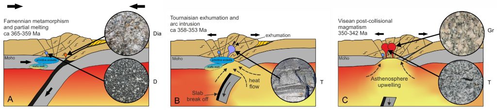
V Malej Fatre a Nízkych Tatrách granitoidné horniny vznikali počas varískej orogenézy pri kolízii prakontinentov Gondwana a Laurázia. Jedným z dôvodov, prečo je potrebné pochopiť ich genézu je známy fakt, že majú rudonosný význam, napríklad ako zdroj antimónu. Potreba riešiť surovinové zdroje tzv. kritických prvkov na využitie v moderných technológiách je aj jednou z úloh geovied v rámci Európskej únie.
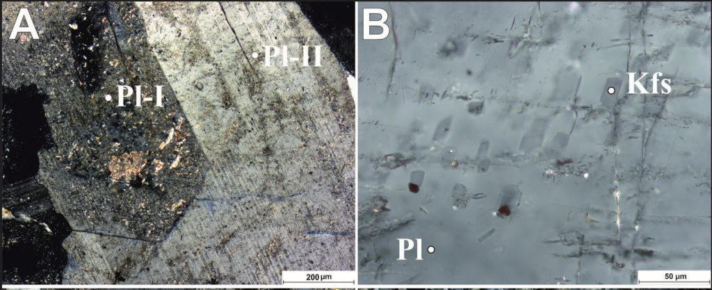
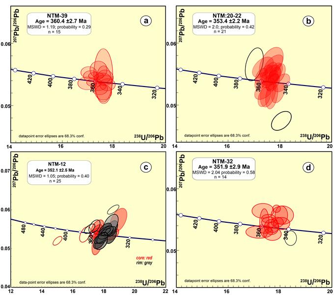
Izotopickým datovaním zirkónov z granitov Malej Fatry sa identifikovali: (1) kolízne anatektické granity (diatexity) s vekom 362 miliónov rokov, (2) málo diferencované granity s vekom 353 miliónov rokov a (3) granity vznikajúce v relatívne krátkom časovom rozpätí cca 347 až 342 miliónov rokov s väčším podielom vytaveného sedimentárneho komponentu, ktoré prenikali až do vrchnej kôry Zeme. Tieto najmladšie varíske granity v Malej Fatre a asi aj na Slovensku vznikali intenzívnejším prísunom tepla pri vyklenutí horúcej astenosféry do vyššej úrovne litosféry Zeme. Vystúpanie resp. vyklenutie plášťovej astenosféry do spodnej kôry bol dôsledok zlomenia ponárajúcej sa kontinentálnej dosky počas kolízie už spomínaných prakontinentov, s čím bola viazaná už prvá generácia granitov s vekom cca 353 miliónov rokov. Mineralogické údaje svedčia o intenzívnejšom miešaní horúcejších pulzov tavenín, ktoré vznikali v čase medzi 347 až 342 miliónmi rokov.
Obdobný proces tvorby granitov so zlomením subdukovanej dosky a tepelným účinkom astenosféry na spodnú kôru sa preukázal aj v Nízkych Tatrách – tu kolízne anatektické granity (diatexity) sú vekovo podobné malofatranským, ale hlavná masa granitov vznikala v rozpätí 353 až 352 miliónov rokov a časovo odpovedá staršej skupine granitov Malej Fatry.
Applied research
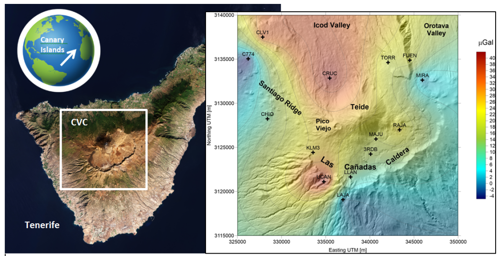
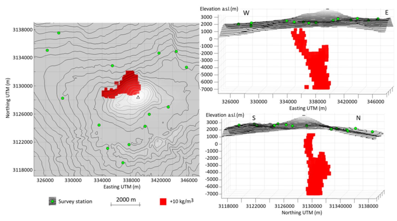
VAJDA, Peter – CAMACHO, Antonio G. – FERNÁNDEZ, Jose. Benefits and Limitations of the growth inversion approach in volcano gravimetry demonstrated on the revisited 2004–2005 Tenerife unrest. In Surveys in Geophysics, 2022, vol. 43, september, p. 527-554, https://doi.org/10.1007/s10712-022-09738-9 (2021: 7.965 – IF, Q1 – JCR, 1.956 – SJR, Q1 – SJR). ISSN 0169-3298.
We revisit the gravimetric imprint of the volcanic unrest of 2004–2005 on Tenerife (Canary Islands). We revise the interpretation of the observed spatiotemporal gravity changes accompanying the unrest by applying the Growth inversion approach based on model exploration and free geometry growing source bodies. We interpret the Growth solution in the context of structural controls.
Our gravimetric picture sees the unrest as a failed eruption, due to a stalled magma intrusion in the central position below the Teide–Pico Viejo stratocones, followed by upward and lateral migration of volcanic fluids reaching the aquifer and the SW end of the caldera wall. The Growth inversion indicates that magma propagated along the boundary between the basaltic core of the island and the more permeable (less compacted) volcanic rocks with lower density.
This gravimetric picture of the unrest provides new insights into the potential future reactivation of the volcanic system.
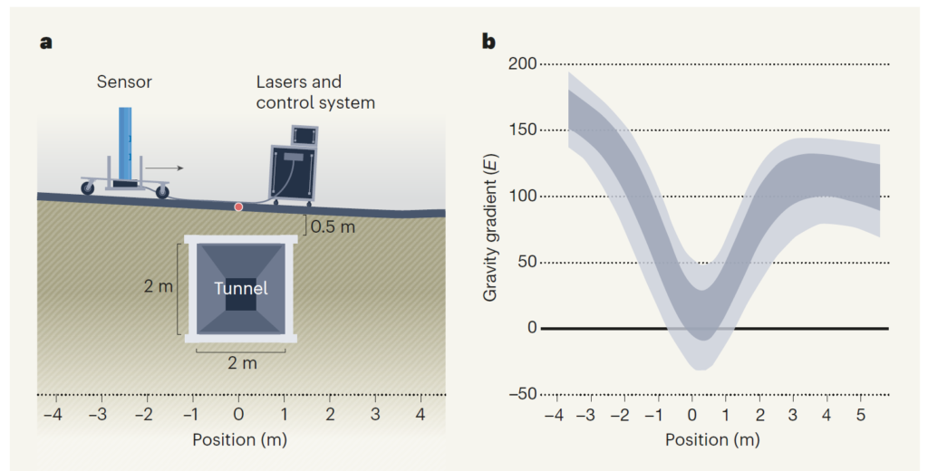
POLI, Nicola – PAŠTEKA, Roman – ZAHOREC, Pavol. Atomic changes can map subterranean structures. In Nature, 2022, vol. 602, no. 7898, p. 579-580. (2021: 69.504 – IF, Q1 – JCR, 17.897 – SJR, Q1 – SJR, karentované – CCC). (2022 – Current Contents, WOS, SCOPUS). ISSN 0028-0836. Dostupné na: https://doi.org/10.1038/d41586-022-00464-1
An article by English authors (Stray et al.: Quantum sensing for gravity cartography) regarding the use of modern quantum technologies in the study of the Earth’s gravity field was published in the journal Nature (Vol. 602, 24 February 2022). Specifically, the authors developed a quantum sensor for measuring the gravity gradient, which is a quantity used quite often in geophysics, and which they themselves demonstrated on the example of identifying an underground tunnel. The main advantage of their sensor compared to classic (non-quantum) gradient measurement is the accuracy, but especially the measurement speed, which opens potentially wide possibilities of use in the future.
The editors of Nature journal invited three experts, Italian physicist Nicola Poli (University of Florence) and Slovak geophysicists Roman Pašteka (Comenius University) and Pavol Zahorec (Earth Science Institute, SAS), to comment on this article. In our contribution (News&views section: Atomic changes can map subterranean structures) we commented mainly on the practical aspects of the possibilities of detecting subsurface objects and the importance of introducing the necessary corrections when processing measurements (the effect of nearby topography and buildings).
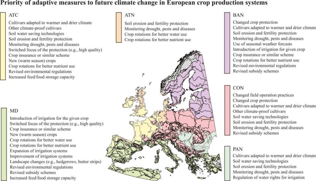
ZHAO, Jin – BINDI, Marco – EITZINGER, Josef – FERRISE, Roberto – GAILE, Zinta – GOBIN, Anne – HOLZKÄMPER, annelie – KERSEBAUM, Kurt Kristian – KOZYRA, Jerzy – KRIAUČI?NIENÉ, Zita – LOIT, Evelin – NEJEDLÍK, Pavol – NENDEL, Claas – NIINEMETS, Ülo – PALOSUO, Taru – PELTONEN-SAINIO, Pirjo – POTOPOVÁ, Vera – RUIZ-RAMOS, Margarita – REIDSMA, Pytrik – RIJK, Bert – TRNKA, Mirek – VAN ITTERSUM, Martin K. – OLESEN, Jörgen Eivind. Priority for climate adaptation measures in European crop production systems. In European Journal of Agronomy, 2022, vol. 138, august, art. no. 126516. (2021: 5.722 – IF, Q1 – JCR, 1.426 – SJR, Q1 – SJR). https://doi.org/10.1016/j.eja.2022.126516
To date, assessing the adaptive measures to climate change effects on cropping systems have generally been based on data from field trials and crop models.
Therefore, we designed a questionnaire that incorporated both qualitative and quantitative aspects of climate change adaptation in the agricultural sector. The questionnaire was distributed to experts from 15 European countries to map both the observed and planned climate adaptive measures in general and for five major crops (wheat, oilseed rape, maize, potato, and grapevine) in six environmental zones across Europe.
In northern Europe, changed timing of field operations and introduction of new crops and cultivars were the already observed as the main adaptations to a longer growing season and reduced low temperature stress under climate change.
Farmers in central and southern Europe were mainly changing water and soil management as well as adopting drought-tolerant cultivars to cope with increasing evapotranspiration and higher variability and lower predictability of rainfall. Crop protection, crop insurance, and early warning/forecast systems were considered effective ways to reduce the economic losses from increased climate-related risks and extremes.
In southern and central Europe, improved irrigation systems, changing cropping systems, and revised environmental regulations and subsidy schemes are being introduced as part of adaptation planning due to the projected warmer and drier climate.
The thorough understanding of the observed and foreseen adaptations in the different zones will be helpful for supporting decision making at both farm and policy levels across Europe.
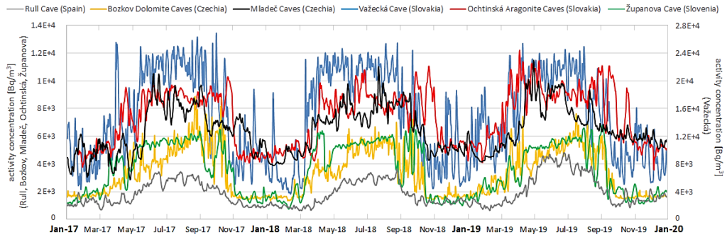
BRIESTENSKÝ, Miloš – AMBROSINO, Fabrizio – SMETANOVÁ, Iveta – THINOVÁ, Lenka – ŠEBELA, Stanka – STEMBERK, Josef – PRISTAŠOVÁ, Lucia – CONCEPTIÓN PLA – BENAVENTE, David. Radon in dead-end caves in Europe. In Journal of Cave and Karst Studies, 2022, vol. 84, no. 2, p. 41-50. (2021: 1.282 – IF, Q4 – JCR, 0.317 – SJR, Q3 – SJR). ISSN 1090-6924. Dostupné na: https://doi.org/10.4311/2021ES0101
MÜLLEROVÁ, Monika – MRUSKOVÁ, Lucia – HOLÝ, Karol – SMETANOVÁ, Iveta – BRANDÝSOVÁ, Alžbeta. Estimation of seasonal correction factor for indoor radon conentration in Slovakia: a preliminary survey. In Journal of Radioanalytical and Nuclear Chemistry-Articles, 2022, vol. 331, no. 2, p. 999-1004. (2021: 1.754 – IF, Q2 – JCR, 0.364 – SJR, Q2 – SJR). ISSN 0236-5731. Dostupné na: https://doi.org/10.1007/s10967-021-08139-3
MÜLLEROVÁ, Monika – HOLÝ, Karol – KUREKOVÁ, Patrícia – SMETANOVÁ, Iveta. Radon monitoring in selected kindergartens in Slovakia. In Radiation Protection Dosimetry, 2022, vol. 198 no. 9-11, p. 766-770. (2021: 0.954 – IF, Q4 – JCR, 0.355 – SJR, Q3 – SJR). ISSN 0144-8420. Dostupné na: https://doi.org/10.1093/rpd/ncac141
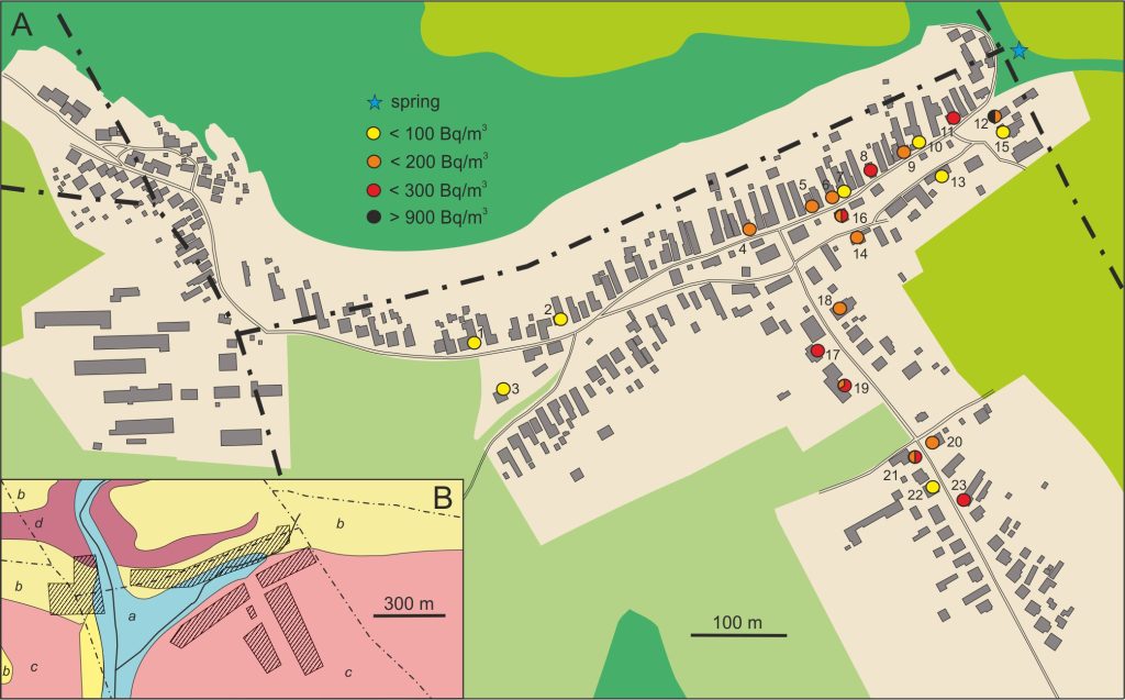
SMETANOVÁ, Iveta – MOJZEŠ, Andrej – CSICSAY, Kristián – MARKO, František. Indoor radon monitoring in selected buildings in Vydrník (Vikartovce Fault, Slovakia. In Radiation Protection Dosimetry, 2022, vol. 198, no. 9-11, p. 785-790. (2021: 0.954 – IF, Q4 – JCR, 0.355 – SJR, Q3 – SJR). ISSN 0144-8420. Dostupné na: https://doi.org/10.1093/rpd/ncac133
The papers are related to radon monitoring in dwellings and show caves.
To test the relation of indoor radon concentration to fault zone, a survey was conducted in buildings in Vydrník, situated close to the Vikartovce fault trace. Monitoring was performed using track detectors during a period of one year, detectors were exposed for three months. Annual average of indoor radon ranged from 60 to 940 Bq/m3.Seasonal variation was confirmed, with minimum in summer months in the majority of rooms. The highest value was detected in a house 12 situated close to the generally E-W trending Vikartovce fault and its intersection with NW–SE trending crosscutting fault.
The identical indoor radon survey was performed in 17 kindergartens situated in medium and high radon risk areas in Slovakia. Annual average of indoor radon ranged between 75 and 1810 Bq/m3. In 11 kindergartens also continuous monitoring was conducted, and significant daily variations were observed, caused by the ventilation of the classrooms. The relationship between radon activity concentrations measured in soil air nearby six kindergartens and indoors has a linear character.
On the base of indoor radon monitoring in 56 rooms throughout the year in four cycles based on 3-month indoor radon measurements using track detectors, the initial seasonal correction factors for Slovakia were determined. Factors for spring, summer, autumn and winter seasons were calculated. The differences between factors for the rooms with and without direct contact with subsoil were negligible. The best agreement between measured and calculated values was obtained using seasonal factors determined for winter season. This factor was applied on independent measurements in 19 rooms, to test their suitability. Measured and calculated annual mean radon concentrations were in a good agreement.
The results of 3-year continuous radon monitoring in six European dead-end show caves were evaluated. Although the radon activity concentrations differed from one cave to another, all caves revealed very similar trends, showing evident seasonal variability with higher values in summer and lower values in winter. The temperature difference between the inside and outside of the caves is the main radon movements driving force.
Research related to international collaboration
TOMAŠOVÝCH, Adam – GALLMETZER, Ivo – HASELMAIR, Alexandra – ZUSCHIN, Martin. Inferring time averaging and hiatus durations in the stratigraphic record of high-frequency depositional sequences. In Sedimentology, 2022, vol. 69, no. 3, p. 1083-1118. (2021: 3.810 – IF, Q1 – JCR, 1.224 – SJR, Q1 – SJR). ISSN 0037-0746. Dostupné na: https://doi.org/10.1111/sed.12936
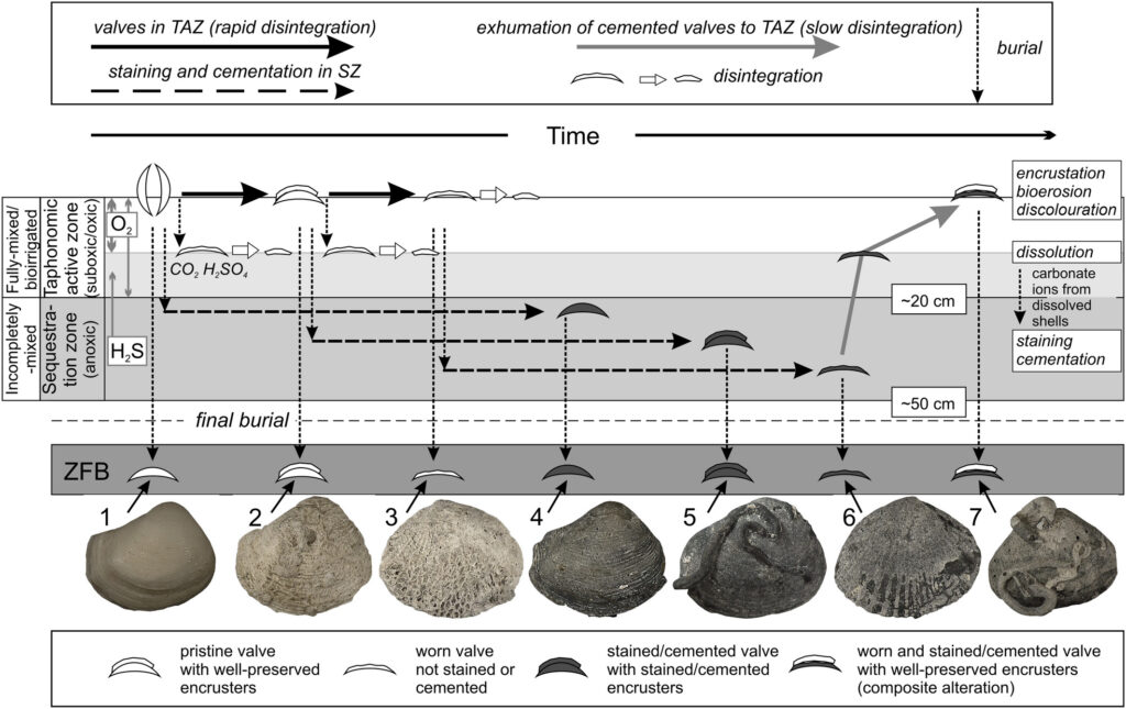
TOMAŠOVÝCH, Adam – GARCÍA-RAMOS, Diego A. – NAWROT, Rafał – NEBELSICK, James H. – ZUSCHIN, Martin. How long does a brachiopod shell last on a seafloor? Modern mid-bathyal environments as taphonomic analogues of continental shelves prior to the Mesozoic Marine Revolution. In Palaeontology, 2022, vol. 65, no. 6, art. no. e12631 (2021: 3.547 – IF, Q1 – JCR, 1.360 – SJR, Q1 – SJR).
The taphonomic (early-diagenetic) clock that measures the residence time of skeletal particles in the mixed layer can be applied to estimate the duration of hiatuses in the pre-Holocene fossil record if the rate of skeletal alteration is slow and if skeletal particles endure long-term exposure in the mixed layer.
We have validated this method on the basis of taphonomic analyses of molluscan preservaton in shallow parts of the Adriatic Sea. We found that median ages of valves stained by pyrite and cemented by high-magnesium calcitic micritic envelopes exceed at least 1000 years and thus indicate that these authigenic diagenetic processes are slow in subsurface zones with reducing conditions (with prolonged sulphate reduction and carbonate ions sourced from dissolved shells in the surface zones, Sedimentology).
In another study, we show that degradation of brachiopod shells in deeper environments of the Adriatic Sea (Bari Canyon – 580 m) is unusually slow, most likely owing to very reduced levels of bioturbation and predation.
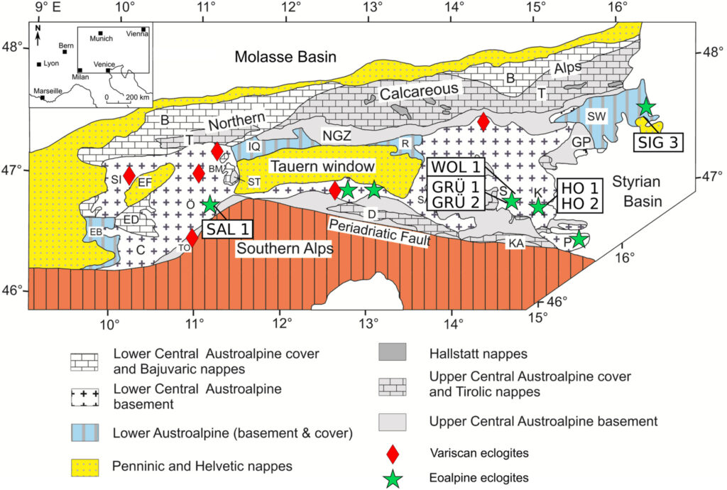
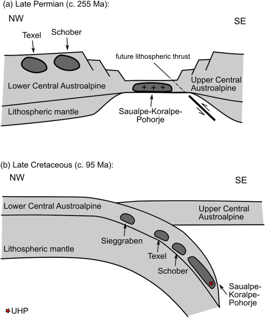
MILADINOVA, Irena – FROITZHEIM, Nikolaus – NAGEL, Thorsten – JANÁK, Marian – FONSECA, Raúl O. C. – SPRUNG, Peter – MÜNKER, Carsten. Constraining the process of intracontinental subduction in the Austroalpine Nappes: Implications from petrology and Lu-Hf geochronology of eclogites. In Journal of Metamorphic Geology, 2022, vol. 40, no. 3, p. 423-456. (2021: 4.472 – IF, Q1 – JCR, 2.210 – SJR, Q1 – SJR). ISSN 0263-4929. Dostupné na: https://doi.org/10.1111/jmg.12634
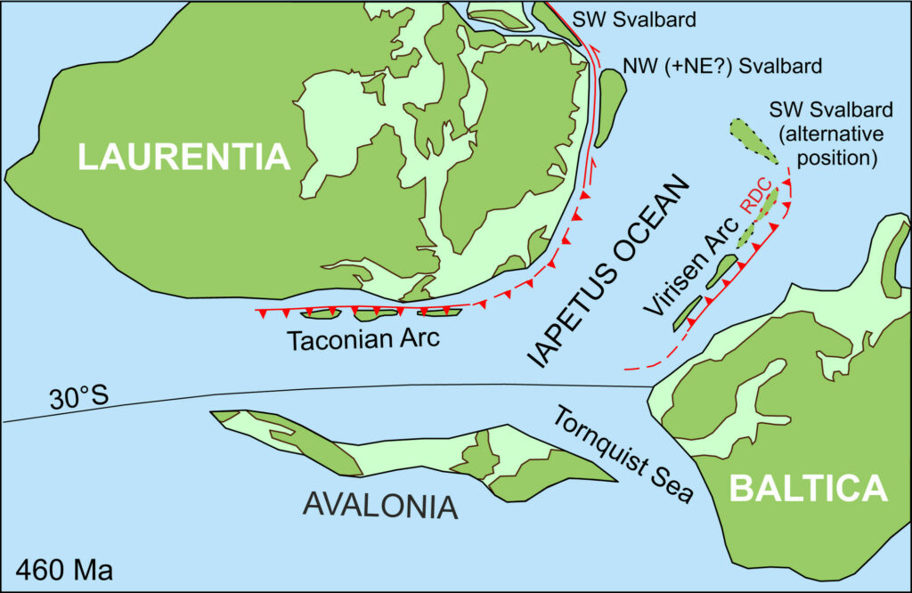
MAZUR, Stanislaw – MAJKA, Jarosław – BARNES, Christopher – MCCLELLAND, William C. – BUKAŁA, Michał – JANÁK, Marian – KOŚMIŃSKA, Karolina. Exhumation of the high-pressure Richarddalen Complex in NW Svalbard: Insights from Ar 40/ 39 geochronology. In Terra Nova, 2022, vol. 34, no. 4, p. 330-339. (2021: 3.271 – IF, Q2 – JCR, 1.214 – SJR, Q1 – SJR). ISSN 0954-4879. Dostupné na: https://doi.org/10.1111/ter.12597
Subduction and exhumation of high-pressure rocks – keys to understanding metamorphism and geodynamics of Earth´s lithosphere in collisional orogens.
Ultrahigh-pressure metamorphism in Austroalpine nappes of the Eastern Alps (Miladinova et al., 2022) is a consequence of intracontinental subduction of lithosphere to ca.120 km depths, documented also by formation of microdiamonds (Janák et al. 2015). Subduction of continental crust occured in Cretaceous time (100-90) recorded by Lu-Hf dating of eclogites, UHP metamorphic conditions were reached in Pohorje area (Slovenia).
The exhumation of high-pressure rocks of the Caledonian orogen in the Svalbard region was documented by geochronological dating of white mica using the Ar-Ar method (Mazur et al., 2022). Subduction and exhumation of the Earth’s lithosphere occurred in the Ordovician period 446-440 million years ago, as a result of the collision of the Baltic continent with the island arc.
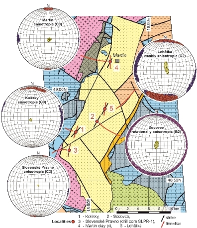
MÁRTON, Emő – KYŠKA-PIPÍK, Radovan – STAREK, Dušan – KOVÁCS, Erika – VIDHYA, Marina – SWIERCZEWSKA, Anna – TOKARSKI, Antoni – VOJTKO, Rastislav – SCHLOGL, Silvia. Enhancing the reliability of the magnetostratigraphic age assignment of azimuthally nonoriented drill cores by the integrated application of palaeomagnetic analysis, field tests, anisotropy of magnetic susceptibility, and the evolution of the endemic fauna as documented on the upper Miocene limnic deposits of the Turiec Basin (Western Carpathians). In AAPG Bulletin, 2022, vol. 106, no. 4, p. 803-827. (2021: 3.863 – IF, Q2 – JCR, 1.292 – SJR, Q1 – SJR). ISSN 0149-1423. Dostupné na: https://doi.org/10.1306/10042120019
One of the tools for determining the development of freshwater basins is to determine the paleomagnetic properties of the deposits, orientation of authigenic magnetic minerals, and age and rotation of the basin compared to today’s north.
The Turiec Basin proved to be a suitable field laboratory, because for the evaluation of paleomagnetic measurements we know the age of volcanic rocks from the bedrock and the succession of sediments based on gradual intralacustrine evolution of endemic fauna. The research was carried out on an azimuthally non-oriented drill core, on which the consistency of the paleomagnetic signal, the early magnetization after the deposition and thus the overall suitability of the sediment core for magnetostratigraphic purposes were determined.
Deposits of four surface locations were also tested. Since the sediments in the borehole were magnetized during a long interval of normal polarity, the age of the sediment formation was estimated at 7.7-8.1 Ma, which corresponds to the Miocene magnetic polarity C4n.2n. It also means that the lacustrine sediments of the Turiec Basin were formed only after the main Miocene rotation of the Western Carpathians. The complex methodology proposed in this way is a suitable tool for solving tasks about freshwater basin development.